Mobile GIS
Table of contents:
Location intelligence is the new buzzword in the industry. What gave new intelligence to location science? What triggered the recent boom of new startups around various applications of location services? A deep dive into these questions reveal the fuel behind these changes as two things: the advancement in smartphone technology and the ecosystem it created; and Mobile GIS. This article discusses the basics of the latter.
License: This article is licensed under the Creative Commons Attribution-ShareAlike 4.0 International (CC BY-SA 4.0) license.
Contrary to the beliefs of the majority (I don’t blame you, I know what it sounds like,) Mobile GIS is not simply the GIS used in Mobile phones. Mobile GIS is a framework developed with integration of software and hardware for access and manipulation of spatial data and the services linked to it using various devices and connected networks. Though the implementation of GIS and other spatial technologies reduced the amount of required fieldwork by a large chunk, it led to the rise of a new problem - that of data collection and data entry. More often than not, these became additional responsibilities of field and desk teams, and this piling up of work subsequently created more frequent, otherwise avoidable errors. Mobile GIS offers a solution for these issues by extending the power of GIS technology from the desk to the field.
One of the biggest changes to occur over the last decade is the status change from “Disconnected” to “Always connected”, thanks to fast-growing network facilities. Fast connecting internet, small devices with larger computational power and cloud infrastructure has brought about a tremendous change in the GIS industry. With the start of 3G and 4G networks, mobile GIS and its associated services have witnessed a radical change in operations. Staying connected to the web made possible real-time/ near real-time updates. This in turn eased the burden on a million other issues ranging from simple data collection to complex problems of city management.
Taking GIS to the field not only sped up the process of data collection but also improved the accuracy of content. Advanced analytics was made available to field level operatives in remote locations. With improved accuracy, solutions became better. Seamless connectivity of the systems in the field, the desk and web servers made the entire process more efficient.
The Technologies
The technologies which enable mobile GIS can be broadly categorised into two: Primary technology and Auxiliary technology. Although this categorisation is subjective and certain technology may jump between being critical or auxiliary, there are some that are absolutely essential in all cases and hence by definition become ‘primary’, like:
Mobile devices
The term Mobile devices is not limited to smartphones and tablets. Devices such as pocket computers, handheld computers or even laptops are considered to be mobile devices. There are certain other sets of dedicated devices solely made for this purpose such as a positioning system in a vehicle or tracking devices.
Positioning system
These enable devices to capture the real-time location at any given time, based on signals from a navigational satellite, by cellular and WiFi networks or by IP addresses. The most recent technological advancement in this field is Radio Frequency Identification (RFID) chips.
Wireless communication system
Wireless communication need not always be a cellular network - depending on the use case, WiFi networks can also be utilised, as long as the core purpose of getting connected to the server for information exchange is fulfilled.
Server/Cloud machines
Server machines either in the cloud network or on the local network are the machines used to collect information from various sources and store it centrally. Requests from remote mobile devices hit the server machines and the responses for the request are processed and disseminated to the respective device by the server.
Auxiliary technologies are all of the supporting technology that can be added for better performance or to provide solutions to a specific issue faced during any stage of the process. Some of the examples of auxiliary technologies are
- 3D GIS
- Artificial intelligence
- Augmented Reality (AR) technology
- Virtual Reality (VR) technology
- Satellite data analytics
- Enterprise Resource Planning (ERP) systems
The concept of location
There are four types of locations
1. The Location of the User
The location of the user who is accessing the service of the GIS application.
2. The location of the data
The location of where the data is stored, whether it be the cloud, the server or the user’s device itself.
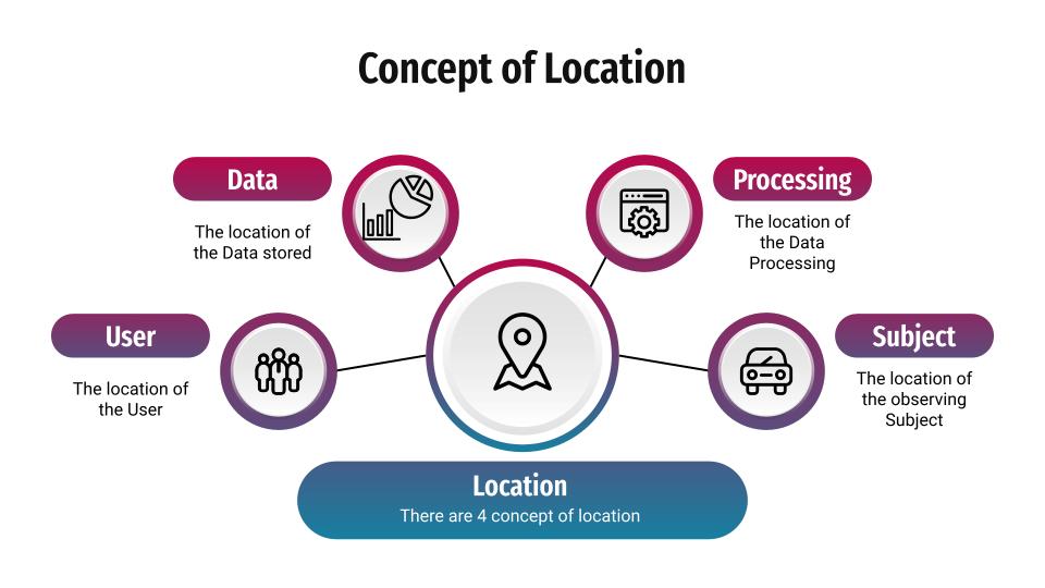
3. The location of the processing
The location where the processing of information takes place. Usually, it is the location of the server machine, but it can also be the user device in case of smaller operations within the scope of their capabilities.
4. The location of the subject
The subject is the feature that is being observed, hence the location of the subject can be defined as the location where the feature is situated. (For example, the location of a valve in the pipeline in the case of a sewage network’s GIS system.).
Some use cases
Navigation
he concept of navigation has changed, it is not simply Point A to Point B anymore. Map applications will give you options to travel from A to B in n number of ways. You can send queries to the system for the roads which do not have toll plazas, you can avoid routes with ferries, you can even choose a route in which you find a restaurant with your favourite cuisine. This all happens in just seconds. Have you ever wondered how this happens? Your requests (mostly predefined queries) are sent to the server, the server performs geoprocessing and returns your results. The raw geodata required for such functions will be stored in the servers in a format that is capable of fast operations, such as points, lines or polygons. But the results are not often saved in servers, they are sent to the user device and stored if required, although, this may differ depending upon the use cases the app is trying to solve.
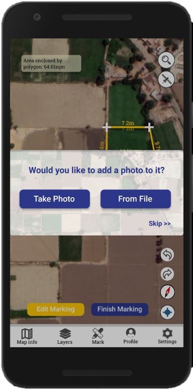
Field Survey made easy
Field Data collection is a tedious task in any project and is a large drain on manpower. Often, the accuracy of the result or study is directly dependent on the accuracy of the data collected. With the evolution of smartphones and various other mobile devices, field data collection is being made easy through various dedicated apps offering a number of features including offline functionality. These advancements not only increased the accuracy and speed of data collection but also reduced the dependency on work and data entry operations, saving a lot of errors, resources and time.
Online Food Delivery and Ride Booking Apps
You may feel that these are simply an extension of navigation algorithms, as they are just routing the service personnel (cab driver/ delivery boy) from the source point to the destination. This is true to an extent. So what’s the difference? The difference is the analytics part of the application, which is not available to the end-users. Have you wondered why you get your deliveries/cabs faster in some parts while slow in other parts? How do the ride/delivery partners know the busiest/most demanding places at a specific point of time? This is where location intelligence comes in. The requests from the end-users are aggregated in the application servers and the busy areas in the location are notified to the partners. Companies also provide bonus compensations to attract the delivery/cab partners and source them towards a point to meet the needs. This is the reason behind that “surge price” you had to pay while returning from that New Year’s party.

GIS in Transportation
Geographic Information Systems for Transportation (GIS-T) refers to the principles and applications of applying geographic information technologies to transportation problems (Miller and Shaw, 2001). Apart from the daily end-user use cases of navigation, The GIS is a problem solver and tool for decision making in different sectors of transportation. Solutions for aviation, marine navigation, railways or even the public transit sector can be found, in a localised or on a global scale. Apart from navigational and tracking activities, one of the major uses in this sector is the study of behavioural changes in the movement of people, goods and vehicles. This involves a long procedure of building datasets, understanding various other auxiliary parameters, modelling the data for solutions and representing the data by transforming it into various other useful formats depending upon the use cases.
![]()
Utility Management
Most of the problems faced in the distribution and management of utility services are due to the lack of proper data and uncertainty in locating the features. Utility services both underground and above ground can be digitised and attached with various other supporting information to a GIS platform. Getting the network into a spatially referenced platform solves half of the issues in locating them on the ground. Mobile GIS techniques can be used in identifying, monitoring, and performing operational activities such as terminating, charging, diverting etc. Auxiliary technologies such as VR/AR can be helpful in augmenting the underground lines over their positions without even digging an inch.
vGIS’s AR solution Augments the underground utility network for locating them on field increases the ease of manageing the services during the on-feild operational works.Digital Twin - The Future
A virtual representation of a process, product, or service is known as a Digital Twin. This fusion of the virtual and real worlds enables data analysis and system monitoring to prevent issues from occurring, reduce downtime, discover new possibilities, and even plan for the future using simulations. Given the growing desire for digital technologies in the smart cities movement, digital twins have become popular in urban planning practice. These digital twins are frequently presented as interactive platforms for capturing and displaying real-time 3D and 4D spatial data in order to simulate urban settings (cities) and the data streams that exist inside them. It takes in and integrates real-time and non-real-time data layers from a variety of sources..
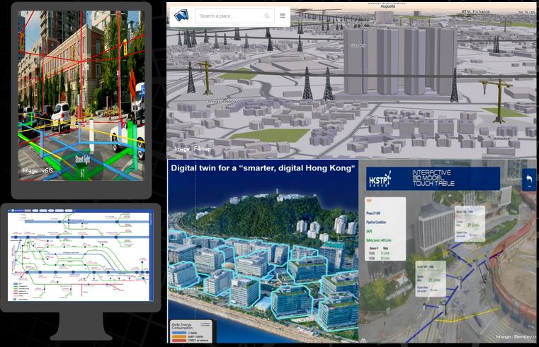
Continuous monitoring and management of the city will be a riskless process with the help of Digital Twin, made possible only with the help of various features of mobile GIS. Imagine a city which has a digital replica and a command and control centre. The administrators could operate the entire city including the traffic, utility networks, movement, transit and much more. We could Design, Operate, Analyse and Redesign a city. We could use predictive analysis reports for a proactive approach to finding solutions, making administration and life easier. Mobile GIS would be the core technology in this case for making every system and sensor connected. On-field data reporting and dynamic solution executions on the go would remain a fantasy without the Mobile GIS components.
Any Comments on the article? Let me know @arkarjun.
PS: All the images/logos used are based on the fair use policy credits to original creators/organisation are mentioned in the images itself. Reuse of those can only be done based on the original licences of the individual image and the author of the article is not responsible for any legal actions.