GeoAI: Making Sense of a New Language


Posts from "Decoding GeoAI" series:
Table of contents:
This article is intended to explain some buzzwords in the modern AI era of Geospatial. This is not a deep dive into the AI concepts but a beginner’s glossary.
License: This article is licensed under the Creative Commons Attribution-ShareAlike 4.0 International (CC BY-SA 4.0) license.
Preface
A couple of months ago, I wrote a mini post asking a question many of us have probably encountered in one form or another: Is AI a threat or an opportunity?
The more I interacted with AI systems, the more I felt that the answer was neither straightforward nor universal. It depended heavily on where you were looking from. For someone working in geospatial technology, the question slowly started taking a different shape. Instead of asking whether AI was a threat or an opportunity, I found myself trying to understand a growing set of new terms that were appearing around me.
GeoAI, Computer Vision, Spatial Intelligence, Foundation Models, Machine Learning
Some of these concepts have existed for years. Others seem to have gained attention only recently. Yet they increasingly appear in conversations around mapping, Earth Observation, agriculture, mobility, urban systems and geospatial products.
This article is the first part of the series Decoding GeoAI, an attempt to make sense of that new language. Not as a researcher or AI specialist, but as a practitioner or as someone observing how AI is slowly finding its place within the geospatial world.
GeoAI - More Than Just Another Acronym
For much of the history of geospatial technology, our focus was on answering:
- What exists at a location?
- How has a place changed over time?
- What is the shortest route between two points?
- Which are the areas most suitable for a particular activity? etc.
The tools evolved over time from paper maps to digital maps, from desktop GIS to cloud-native platforms, and from manually interpreted satellite imagery to automated pipelines and workflows. Yet the underlying objective remained largely the same: turning spatial data into actionable insights. Over the last few years, however, a new term has begun appearing more frequently in geospatial conversations: GeoAI.
At first glance, GeoAI may appear to be simply another buzzword or an umbrella term; Geospatial Artificial Intelligence can be the convergence of artificial intelligence with geospatial technology. But the more I encountered the term, the more I realised that it represents something broader than a single technology or tool.
GeoAI sits at the intersection of several disciplines: Geographic Information Systems (GIS), Remote Sensing, Artificial Intelligence, Machine Learning, Spatial Statistics, Big Data and Cloud Computing. Rather than being a separate field replacing GIS or Remote Sensing, GeoAI can be viewed as an evolution of how we analyse and derive insights from geospatial data.
Why Did GeoAI Emerge Now?
Today, satellites capture images of the Earth almost continuously. Drones collect high-resolution imagery. Smartphones generate location traces. Sensors monitor everything from weather conditions to vehicle movement. The challenge now is no longer collecting data - it is making sense of it. Consider a simple example: Imagine being tasked with identifying all newly constructed buildings in a district. A decade ago, this might have involved analysts visually comparing satellite images and digitising features manually. While accurate, the process would be time-consuming and difficult to scale.
Today, AI models can be trained to detect buildings automatically from imagery, highlight areas of change, and assist analysts in validating results. The objective remains the same - mapping buildings - but the approach has changed dramatically. This shift from manual interpretation to intelligent automation is one of the driving forces behind GeoAI.
GeoAI in Everyday Life
While the term may sound like jargon or specialised, many of us interact with GeoAI-powered systems regularly.
- When a ride-hailing app predicts an arrival time, it is not simply calculating distance. It is analysing traffic patterns, road networks, historical movement data, and current conditions.
- When agricultural advisories identify crop stress from satellite imagery, AI models are often helping detect patterns that would be difficult to identify manually across thousands of farms.
- When disaster response teams assess flood extents or damaged infrastructure using satellite images, AI-assisted workflows increasingly support rapid analysis. In each of these examples, location is central to the problem, and AI is helping process information at a scale that would be difficult through traditional methods alone.
A New Language Emerging
What makes GeoAI particularly interesting is that it introduces a new vocabulary into a field that already has its own language. Terms such as Machine Learning, Computer Vision, Foundation Models, Spatial Intelligence, AI Agents, and Vector Databases are becoming increasingly common in geospatial discussions. Understanding GeoAI, therefore, is not only about understanding a technology. It is also about understanding the language that is beginning to shape the future of geospatial systems. And that language starts with a few key concepts. While each represents a distinct concept, together they help explain why GeoAI feels different from traditional geospatial workflows.
Let’s start with one of the most commonly used terms: Machine Learning
Machine Learning
Machine Learning, although not new to the industry, cannot be ignored in this discussion because it forms one of the fundamental building blocks of modern AI.
Let’s decode Machine Learning in geospatial terms.
Traditional GIS workflows are often rule-based. If a pixel has certain characteristics, classify it as a particular theme, say vegetation. If a road is blocked, calculate an alternative route. The rules are explicitly defined by humans.
Machine Learning approaches the problem differently. Instead of specifying every rule, we provide examples and allow the system to learn patterns from data.
To understand this, let me take something I built during my college days - a recommendation system. You might have seen messages on e-commerce websites such as, “People who bought X also bought Y.” One of the techniques behind such recommendations is Collaborative filtering algorithm. The idea is simple: people who showed similar preferences in the past are likely to show similar preferences in the future. I used this recommendation system with geospatial data for LoReS which recommends properties to a user.
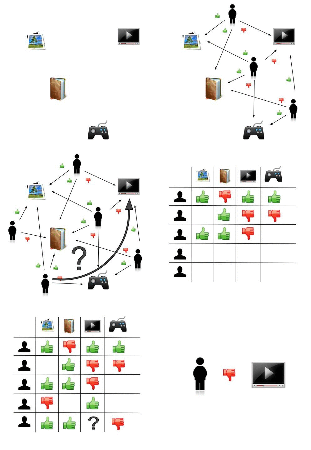
An example of predicting of the user’s rating using collaborative filtering. Source: Commons

Rather than hard-coding rules for every product and every customer, the system learns patterns from historical behaviour and uses those patterns to make predictions.
In many ways, Machine Learning in geospatial applications works similarly.
Instead of manually defining the characteristics of every crop type, land-use category, or settlement pattern, we provide examples (training samples) and allow the model to learn from them. Once trained, it can identify similar patterns across larger areas and datasets.
Sounds familiar?
Yes, this is very similar to what many of us have been doing through supervised classification workflows. We provide representative samples, allow the system to learn their characteristics, and then use that knowledge to classify the remaining data.
The difference is that modern Machine Learning approaches can often handle larger volumes of data, more complex relationships, and a wider variety of inputs than traditional classification methods. Whether it is classifying crops from satellite imagery, predicting flood-prone areas, or identifying changes in urban growth, Machine Learning is essentially helping us recognise patterns at a scale that would be difficult to achieve manually.
Computer Vision
If Machine Learning helps us learn patterns from data, Computer Vision extends that idea to images.
For the geospatial industry, imagery has always been one of the richest sources of information. From aerial photographs and drone surveys to the continuous stream of observations coming from Earth observation satellites, we have never had a shortage of imagery. The challenge has often been interpreting this ever-growing volume of visual data efficiently and consistently.
Traditionally, this interpretation was performed by trained analysts. Computer Vision attempts to teach computers to perform similar tasks of identifying, classifying, and extracting information from images at a scale that would be difficult for humans alone. Much of remote sensing has traditionally involved teaching humans to interpret imagery while the same trajectory of evolution now attempts to teach computers to do the same. The feature detection is the very classic example for this. When a computer program identifies a building as a building or a car as a car from the image provided thats computer vision algos running behind it. When this process is applied to geospatial imagery, we begin to see Computer Vision operating within a geospatial context. You might have used the Google’s open building datasets, those are excellent examples of this. What appears to be a simple collection of building footprints is actually the result of solving a highly complex Computer Vision problem across vast amounts of satellite imagery. Ever thought of digitising every single building for a project in a densely populated area? Now you could simply ingest OpenStreetMap data or Google building to your work and focus on the actual problem.
Spatial Intelligence
Recognising a building or a road or even flooded areas in an image is impressive. But the real world problems rarely stop at recognising objects. Understanding how those objects relate to each other, how they connect, and how they interact within a landscape requires another layer of intelligence which is called as the Spatial Intelligence.
Let me explain this with an example.
Imagine a set of buildings detected from satellite or drone imagery using Computer Vision algorithms. Separately, a flood simulation model, built using Machine Learning techniques, predicts the areas likely to be affected by flooding. When these datasets are combined with information such as road networks, elevation, and accessibility, another layer of analysis emerges.
Spatial Intelligence enables us to understand the relationships between these different datasets. Instead of simply identifying flooded areas or mapping buildings, it can help answer more meaningful questions: Which buildings are most vulnerable? Which communities may become isolated? Which locations require immediate evacuation? What is the safest route for emergency response teams?
In this case, the intelligence comes not from recognising individual objects, but from understanding how those objects relate to each other in space. How is Spatial Intelligence new? Haven’t we been doing this all along?
The answer is yes. Spatial Intelligence itself is not new.
Geospatial professionals, planners, disaster managers, and domain experts have been applying spatial intelligence for decades. Every time a planner evaluates the best location for a public facility or an emergency responder prioritises areas for evacuation, they are reasoning about spatial relationships.
What is changing with GeoAI is not the concept itself, but the scale and speed at which such reasoning can be supported. AI systems can process thousands of buildings, road segments, and observations simultaneously, helping humans identify patterns and relationships that would otherwise take significant time and effort to uncover. Recalling my war room memory in Vijayawada during Andhra Floods in 2024, despite deploying dozens of drones and capturing footage of flood sites, authorities struggled to act in real time. The bottleneck wasn’t data collection; it was interpretation. If a spatially intelligent system were there, the results would have been much more impactful.
In many ways, GeoAI is not replacing spatial intelligence; it is attempting to augment it.
Some Closing Notes
The terms explored in this article: GeoAI, Machine Learning, Computer Vision, and Spatial Intelligence are by no means new. Many of the underlying ideas have existed for years, and in some cases, decades. What appears to be changing is the way these concepts are converging within the geospatial domain. Problems that once required significant manual effort can now be approached with increasing levels of automation, while the scale of analysis continues to grow. As someone working in geospatial technology, I find it useful to think of GeoAI not as a single technology, but as a collection of ideas, tools, and approaches that are gradually becoming part of our everyday vocabulary. And like any new language, understanding the basics is often the first step.
In the next part of Decoding GeoAI, I’ll explore some of the newer terms that are beginning to shape GeoAI conversations, including Foundation Models, AI Agents, Geospatial RAG, and Digital Twins.
Any comments on the article, let me know @arkarjun or @Medium.