GeoAI: Understanding The New Grammar


Posts from "Decoding GeoAI" series:
Table of contents:
This is the second part of the Decoding GeoAI series, an attempt to make sense of that new AI language. It’s meant to explain some buzzwords in the modern AI era of Geospatial, not a deep dive into the AI concepts, more of a beginner’s glossary.
License: This article is licensed under the Creative Commons Attribution-ShareAlike 4.0 International (CC BY-SA 4.0) license.
Preface
In the first part of this series, GeoAI: Making Sense of a New Language, I went through some of the new words that have become part of the GeoAI vocabulary, Machine Learning, Computer Vision, Spatial Intelligence, and how each helps machines learn from data, understand imagery, and reason about the world around us. Understanding those terms is a good starting point, but words alone rarely tell the whole story.
A language is more than its vocabulary, and modern AI is more than a collection of models and algorithms. The real shift is in how these ideas connect and build on one another.
To understand why today’s AI feels fundamentally different from the AI many of us have used for years, we need to understand its new grammar.
What Changed?
Machine Learning has been around for decades. Computer Vision isn’t new either. Yet in the last couple of years, AI has suddenly become capable of holding conversations, generating reports, writing code, creating images, and solving problems that felt out of reach not long ago.
The answer doesn’t lie in a single breakthrough. It comes from a handful of ideas that have gradually reshaped modern AI, and the biggest shift among them is the move from task-specific Classical AI to general-purpose Generative AI, made possible by concepts like Foundation Models and Embeddings.
From Classical AI to Generative AI
Today, when someone says AI, the first thing that comes to mind is usually ChatGPT or something like it. We ask it questions, generate reports, write code, create images, brainstorm ideas. That’s introduced a new phrase into the vocabulary: Generative AI.
Which raises an obvious question. Wasn’t the AI we were already using also AI?
Yes.
The AI used for image classification, object detection, route optimisation, recommendation systems, anomaly detection, and countless geospatial workflows is usually called Classical AI (or Traditional AI). These systems are built to do one specific job. Given an input, they learn patterns and produce a prediction, classification, or decision, nothing more, nothing less. Their objective is narrowly defined by the task they were trained to solve.
Let’s continue with the building mapping example from the previous article. A classical AI model might look at an image and answer one specific question, “Is there a building here?” Or maybe, “Draw the footprint of every building in this image.” The output is focused, deterministic, and tied to exactly the task the model was trained for.
Generative AI works differently. Instead of being limited to one predefined question, it can interact with the same data in far more flexible ways. Instead of only identifying or classifying information, it can generate new content based on what it has learned.
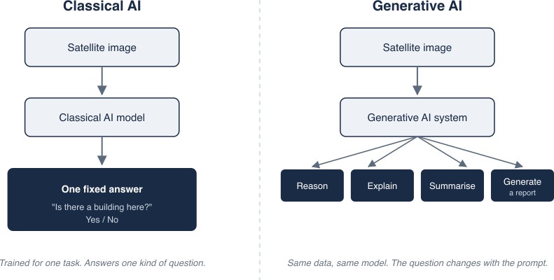
Same underlying data, two different ways of working with it.
Using the same building dataset, a Generative AI system could answer questions like:
- Summarise the pattern of urban growth in this city.
- Describe the differences between these two neighbourhoods.
- Generate a report highlighting areas where building density has increased significantly.
- Explain which regions may need additional public infrastructure based on recent development.
The underlying geospatial data hasn’t changed. What’s changed is how we interact with it. Instead of just asking a model to recognise patterns, we can now ask it to reason about them, explain them, summarise them, and communicate them in plain language.
At this point, a natural question comes up. Where did all this information actually come from? If a Generative AI system can summarise urban growth or explain changes in a city, someone (or something) still has to identify the buildings, measure the changes, and produce the underlying data first.
In most GeoAI systems, that’s still the job of Classical AI and geospatial analytics. Computer Vision detects the buildings, Machine Learning identifies the patterns, GIS runs the spatial analysis, statistical models quantify the change. Generative AI builds on top of all of that, helping us explore, explain, and communicate the results in natural language.
Generative AI sits on top of Classical AI, not in place of it. One helps us understand the world, the other helps us understand what that understanding means.
But there’s a gap here. A Generative AI system was never specifically trained to analyse urban growth, compare neighbourhoods, write reports, answer follow-up questions, or explain planning decisions. So how is it doing all of this?
Large Language Models (LLMs)
The systems we interact with today, ChatGPT, Gemini, Claude, are examples of Large Language Models (LLMs). Generative AI describes the capability of generating human-like content; an LLM is one of the technologies that makes that capability possible.
Unlike traditional machine learning models built for a single task, LLMs are trained to understand and generate human language across a wide range of tasks. There’s no separate model to answer questions, another to summarise documents, another to write reports. The same model does all of it, you just change the prompt.
That flexibility is what makes modern AI feel fundamentally different from what many of us have used for years. But it pushes the question one step further. How does a single model get this versatile without being trained separately for every possible task? The answer is another concept that’s become central to modern AI: Foundation Models.
Foundation Models
If Large Language Models are what most of us interact with today, Foundation Models are one of the key technologies behind them. Traditionally, AI models were built for one problem at a time. A model trained to detect buildings knew about buildings. A model trained to classify crops knew about crops. If you wanted to solve a different problem, you trained a different model.
Foundation Models take a different approach. Instead of learning one task, they first learn broad representations from enormous, diverse datasets. Rather than teaching a model only about buildings or only about roads, you expose it to millions, sometimes billions, of examples, and it develops a much richer sense of patterns and relationships on its own.
Back to the building mapping example. Say you build an excellent building detection model using satellite imagery from Bengaluru. It performs well because it has learned exactly what buildings look like in that region.
Now deploy the same model in Nairobi or Amsterdam or a smaller Indian city like Jaipur.
Performance drops. Building materials are different. Roof colours change. Density and layouts vary. The imagery comes from a different sensor. Even the season can change how a building appears. Traditionally, the fix was to collect fresh training data and retrain the model for every new region or task.
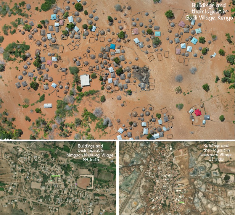
Building and their layouts placements in (Top)Kenya [Source: Kenya Red Cross via OpenAerialMap], (Bottom right) Maharashtra, (Bottom left) Gujarat [Source: Bharat Maps Via NIC] .
Foundation Models exist to cut down on that repeated effort. Instead of starting over every time, they learn general representations from vast, diverse imagery, covering different landscapes, climates, settlement patterns, and geography, before being adapted to a specific task. Rather than memorising what buildings look like in one city, they learn the broader concepts of shape, texture, spatial relationships, and context, concepts that transfer across environments.
Hand it a new city and the model isn’t starting from zero. It already has a broad understanding of the visual world and just needs to adapt that knowledge to the new task. This goes well beyond building detection too. The same approach now applies to roads, land cover, disaster assessment, environmental monitoring, and plenty of other geospatial problems.
A useful analogy here is learning to read. If you already know a language, reading a new book is far easier than learning the language from scratch, the words change but the underlying understanding is already there. Foundation Models work the same way. Learn a general representation first, specialise later. It’s a big part of why they’ve drawn so much attention within GeoAI.
Earth observation programmes have collected decades of satellite imagery covering almost every corner of the planet. Those archives hold an enormous amount of information about how the world looks and how it changes over time. Foundation Models give us a way to learn from that data before tackling any individual application.
For the geospatial community, this changes what a new project can start from. Instead of building an isolated model every time, we can increasingly start with a model that already understands a lot about the Earth’s surface, and adapt it to building extraction, road detection, disaster assessment, land-cover mapping, or environmental monitoring.
Foundation Models aren’t a silver bullet though. They still need careful evaluation, domain knowledge, and good data. Local conditions, specialised applications, and changing environments usually demand extra fine-tuning and validation.
Foundation Models in Earth Observation
The idea of Foundation Models isn’t limited to language either, the same philosophy is now showing up in Earth Observation, where researchers are building them from enormous archives of satellite imagery collected over decades.
A few organisations are already building Earth Observation Foundation Models, each with a different focus.
| Model | Developed by | Focus | Trained on |
|---|---|---|---|
| Prithvi | IBM and NASA | Floods, burn scars, crop yield, disaster monitoring | Harmonised Landsat and Sentinel-2 (HLS) |
| Clay | Clay Foundation, backed by Radiant Earth | Multimodal geospatial embeddings | Sentinel-1, Sentinel-2, elevation data |
| SatMAE | Stanford SustainLab | Self-supervised pre-training on multi-spectral, temporal imagery | Multi-spectral, temporal satellite imagery |
Different architectures, different training strategies, same philosophy: learn broadly first, specialise later.
Here’s what that looks like outside a research paper. Prithvi was recently uploaded to a satellite in orbit and tested on real flood and burn-scar detection, predictions generated far from any data centre.
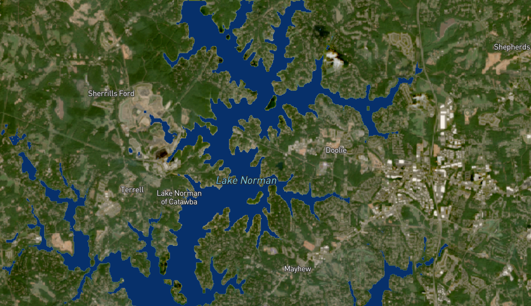
Prithvi’s prediction of flood extent (blue) around Lake Norman, North Carolina, after Hurricane Helene, October 2024. Image: NASA
Closer to home, Dhaarini from SatSure shows this is becoming an active area within India’s geospatial ecosystem too.
Maybe the real shift isn’t that Foundation Models know everything. It’s that they give us a much stronger starting point than before.
Here’s the thing though. If a Foundation Model has learned from billions of examples, what does it actually do with all of that, how does it represent that knowledge internally? That’s where the next term comes in: Embeddings.
Embeddings
If a Foundation Model has seen billions of satellite images, it clearly isn’t storing every one of them somewhere. So what has it actually learned? The answer is Embeddings.
Show a Foundation Model two satellite images. One is a residential neighbourhood in Bengaluru. The other is a similar neighbourhood in Nairobi. The buildings look different. The roof colours are different. The road layouts vary. Even the surrounding vegetation is different. And yet the model recognises both as similar urban environments.
How? It isn’t comparing pixels. It converts each image into a compact mathematical representation of what it understood about that image. That representation is called an embedding.
Think of an embedding as a summary of everything the model has learned about an object. For a building, that might mean its shape, texture, surrounding context, roof pattern, nearby roads, or whatever else the model has learned matters. Instead of remembering every pixel, it remembers these characteristics.
Geospatial professionals have been simplifying the real world for decades already. A building polygon is not the building itself. A road centreline is not the actual road. A land-cover class is not every tree and every blade of grass. They’re simplified representations that capture the information we actually care about. Embeddings do the same job for AI.
An embedding is the model’s internal representation of what it understood from an image, not the image itself. Because similar objects produce similar embeddings, the model recognises relationships it was never explicitly taught. Buildings with similar characteristics end up with similar embeddings. Road networks with similar patterns produce similar representations. Agricultural fields with comparable spatial and spectral characteristics land close to each other. It compares meaning, not pixels.
This is also why Foundation Models transfer so well between tasks. Whatever they learned during pre-training is stored in these internal representations. Adapting the model to a new task isn’t teaching it from zero, it’s helping it apply what it already knows.
As AI systems get more capable, embeddings aren’t just used inside Foundation Models anymore. They’ve become a kind of common language, a way to represent and compare images, text, maps, documents, and plenty of other kinds of information. Get a handle on embeddings and a lot of modern AI starts making more sense: semantic search, Retrieval-Augmented Generation (RAG), multimodal AI, geospatial assistants that can actually reason about a map.
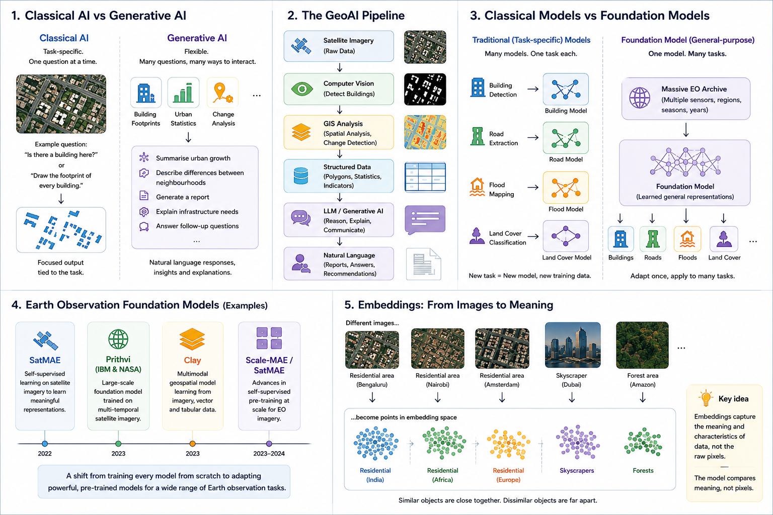
AI Generated summary infographics
I’ll get into those in the next part. Any thoughts on this one, let me know @arkarjun.